Weather in Pottendorf – today and the next few days
There is currently no official weather warning for Pottendorf (GeoSphere Austria, as of today, 02:22).
Pottendorf · Today, 15 Nov · calculated for 02:30
- Feels like
- −1.9 °C
- Today
- high 6°, low −1°
- Rain
- No precipitation in sight until 02:00 tomorrow.
- Wind
- 26 km/h from SE, gusts 41 km/h
- Humidity
- 72 %
- Sun
- 06:58 to 16:19
Calculated for the centre of Pottendorf (1 km grid) – source: GeoSphere Austria, INCA nowcast.
Measured at the Hornstein weather station (5.6 km away):
3.5 °C at 02:10.
River levels
223 cm measured today, 01:55
146 cm measured today, 01:55
116 cm measured today, 01:55
Centimetres above the zero point of the gauge – not the water depth, and not comparable between stations. Unchecked raw data from the State of Lower Austria.
The next 24 hours
Scroll sideways. Temperature on the hour, precipitation and weather for the hour before. Source: GeoSphere Austria, model with 1 km resolution, run of 14 Nov, 19:00.
The same values as a table
| Time | Temperature | Weather | Precipitation | Wind | Gusts |
|---|---|---|---|---|---|
| 03:00 | 2.4 °C | Clear | 0 mm | 33 km/h | 55 km/h |
| 04:00 | 2.8 °C | Clear | 0 mm | 35 km/h | 58 km/h |
| 05:00 | 2.5 °C | Clear | 0 mm | 32 km/h | 57 km/h |
| 06:00 | 2.3 °C | Mostly cloudy | 0 mm | 29 km/h | 52 km/h |
| 07:00 | 2.4 °C | Partly cloudy | 0 mm | 32 km/h | 51 km/h |
| 08:00 | 2.7 °C | Mostly cloudy | 0 mm | 32 km/h | 51 km/h |
| 09:00 | 3.5 °C | Mostly cloudy | 0 mm | 33 km/h | 53 km/h |
| 10:00 | 4.5 °C | Mostly cloudy | 0 mm | 34 km/h | 56 km/h |
| 11:00 | 5.3 °C | Overcast | 0 mm | 31 km/h | 56 km/h |
| 12:00 | 6.1 °C | Mostly cloudy | 0 mm | 33 km/h | 54 km/h |
| 13:00 | 6.2 °C | Mostly cloudy | 0 mm | 31 km/h | 55 km/h |
| 14:00 | 5.9 °C | Overcast | 0 mm | 30 km/h | 52 km/h |
| 15:00 | 5.7 °C | Overcast | 0 mm | 27 km/h | 50 km/h |
| 16:00 | 5.2 °C | Overcast | 0 mm | 22 km/h | 46 km/h |
| 17:00 | 4.3 °C | Overcast | 0 mm | 20 km/h | 38 km/h |
| 18:00 | 3.3 °C | Partly cloudy | 0 mm | 19 km/h | 33 km/h |
| 19:00 | 2.7 °C | Mostly cloudy | 0 mm | 17 km/h | 31 km/h |
| 20:00 | 1.6 °C | Mostly cloudy | 0 mm | 9 km/h | 27 km/h |
| 21:00 | 0.5 °C | Partly cloudy | 0 mm | 3 km/h | 16 km/h |
| 22:00 | −0.4 °C | Mostly cloudy | 0 mm | 2 km/h | 7 km/h |
| 23:00 | −0.8 °C | Overcast | 0 mm | 2 km/h | 2 km/h |
| 00:00 | −0.6 °C | Overcast | 0 mm | 3 km/h | 3 km/h |
| 01:00 | 0 °C | Overcast | 0 mm | 4 km/h | 6 km/h |
| 02:00 | 0.1 °C | Overcast | 0 mm | 4 km/h | 7 km/h |
The next 5 days
- Today, 15 Nov Mostly cloudydry · gusts up to 58 km/h −1° 6°
- Tomorrow, 16 Nov Overcast0.2 mm 0° 5°
- Tuesday, 17 Nov Light rain98% chance of rain · 1.9 mm 1° 9°
- Wednesday, 18 Nov Light rain76% chance of rain · 1.9 mm 5° 15°
- Thursday, 19 Nov Light rain20% chance of rain · 1.2 mm 2° 13°
Low and high for each day. Days from the 1 km model of GeoSphere Austria, then weather data © OpenWeather (chance of rain = highest probability of the day). The further away a day is, the less certain the forecast.
Weather news from the region
These news items come from our German newsroom and are in German.
 14 Nov 2026 Hundertjähriger Kalender: Schnee am 1. Dezember in Baden?
Berichte nennen den 1. Dezember als Schneetag laut Hundertjährigem Kalender. Die Ausgabe von 1712 sagt etwas anderes, und eine Prognose für Baden gibt es noch nicht.
 13 Nov 2026 Wetter in Baden: Sonniges Wochenende mit Morgenfrost
Nach Regen und Sturmböen wird es in Baden ab Freitagabend trocken. Der Samstag bringt viel Sonne, beide Morgen starten um den Gefrierpunkt. Am Sonntag kann Nebel im Wiener Becken hängen, dazu weht Südostwind.
 4 Nov 2026 Nebel und Nässe auf A 2 und A 21: was Pendler beachten
Fast 98.000 Fahrzeuge am Tag auf der A 2 bei Bad Vöslau, jeder sechste ein Lkw auf der A 21 bei Alland: Was bei Nebel und Regen gilt, welche Fehler oft passieren und wo du vor der Fahrt nachsiehst.
 3 Nov 2026 Hochwasser 2024: Klimawandel trieb die Flutspitzen hoch
Eine neue Studie zu Sturm Boris zeigt: Der Klimawandel hat den Regen im September 2024 um einige Prozent verstärkt, die Hochwasserspitzen aber um bis zu 22 Prozent. Was damals in Baden und im Triestingtal passierte und was daraus folgt.
 3 Nov 2026 Halber Meter Schnee? Was die Prognose für Baden heißt
Die 50 Zentimeter Neuschnee aus den Schlagzeilen stammen aus einer einzelnen Modellrechnung für Westösterreich ab 10. November. Für Baden zeigt die Vorhersage bis zum Wochenende Nebel, Sonne und leichten Nachtfrost.
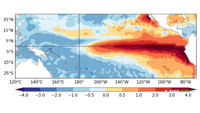 1 Nov 2026 Starker El Niño: Für Badens Winter sagt er wenig aus
Die NOAA rechnet mit einem starken El Niño bis ins Frühjahr 2027. Für den Winter im Bezirk Baden heißt das wenig: Laut GeoSphere Austria kommen seine Signale in Österreich nur abgeschwächt und unzuverlässig an.
All news from the district → (in German)
Weather in the Baden district
More about Pottendorf: events, businesses and news from Pottendorf.
Sources: GeoSphere Austria (Data Hub, licence CC BY 4.0) for current values, hourly forecast, weather stations and warnings; weather data © OpenWeather for the later days; river levels: State of Lower Austria. Nowcast as of today, 02:12, model today, 01:52, OpenWeather 14 Nov, 23:52.
Where the figures come from – and what they are not
The current value is calculated, not measured. Every 15 minutes, GeoSphere Austria uses INCA to calculate temperature, wind and precipitation on a one-kilometre grid – from weather stations, radar and satellite. We read the value for the centre of the town. The nearest weather station is shown separately below it, with its distance, because a station a few kilometres away or higher up can have noticeably different values.
The hours come from GeoSphere Austria's weather model with 1 km resolution, which recalculates every three hours and looks about two and a half days ahead. The later days come from OpenWeather in 3-hour steps. Our access offers no more than five days, so we don't show more.
Precipitation is the expected amount in millimetres. A probability is only available for the OpenWeather days; it is the highest value of the day. If a value is missing, there is a dash – 0 mm means dry, a dash means unknown.
Official warnings are requested from GeoSphere Austria every five minutes for exactly this location, and we show the text unchanged (in German). If the request fails, it says so at the top – that is not an all-clear. The official warning map (in German) is binding.
Feels-like temperature is our own calculation: below 10 °C with the wind chill formula from temperature and wind, from 27 °C with the heat index from temperature and humidity. In between it equals the air temperature. Sunrise and sunset are calculated too.
River levels are unchecked raw data and refer to the zero point of each gauge. More on the river levels page.